
Maps for events taking place of the 3rd of November, with forty-one years separating the two.
The first is a simple plan of a dramatic day’s action, ‘Bombardment & capture of Acre, November the 3rd 1840′. The map shows both the layout of the citadel of Acre, now a coastal town on the Mediterranean in Israel but at the time part of the Ottoman Empire, and the ships of the British, Turkish and Austrian navies who bombarded the Egyptian forces that had taken control of the Citadel as part of a campaign to gain control of Ottoman territory.
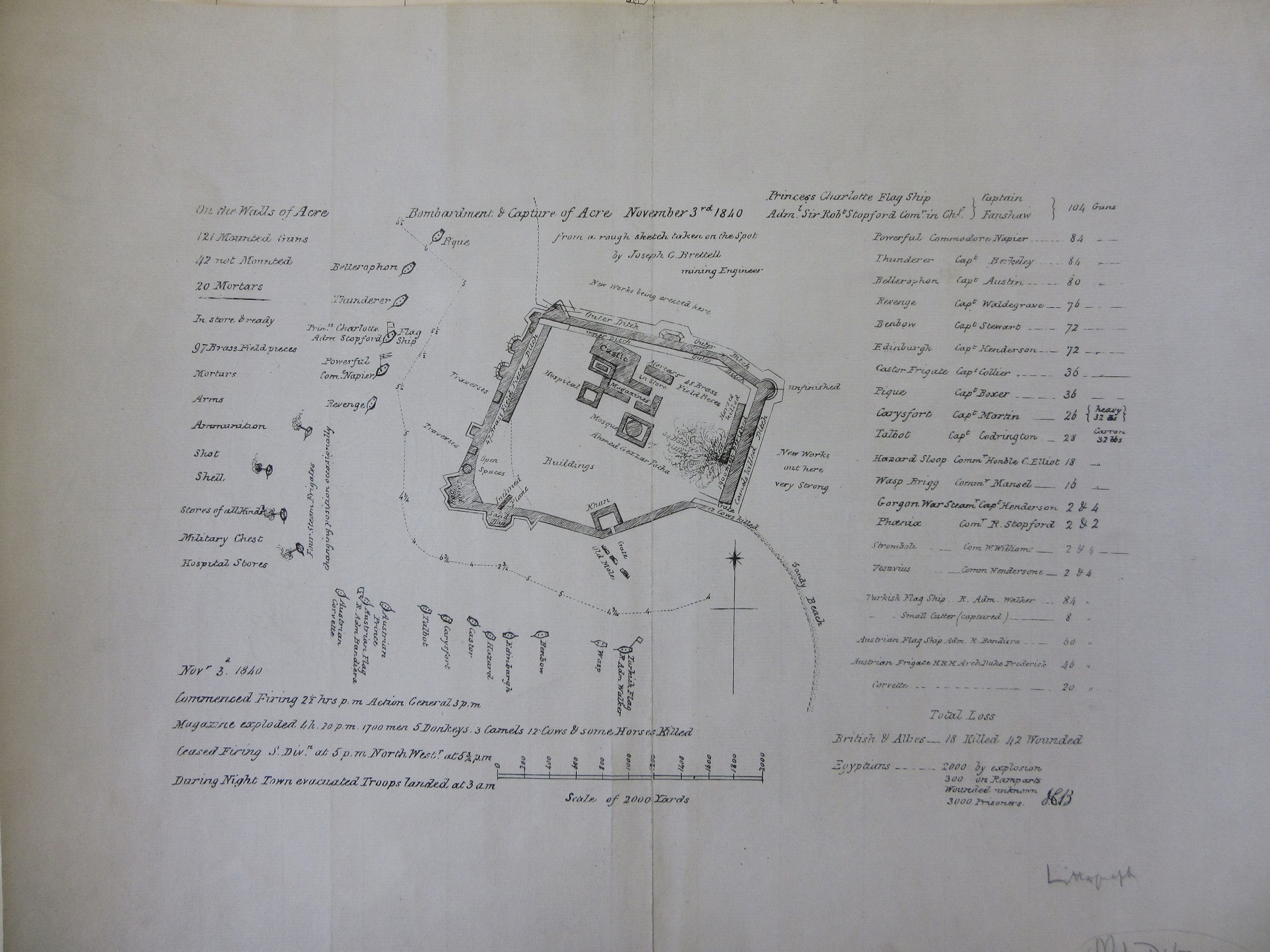
Despite its small size the map is full of detail, giving not just a list of ships with captains and guns but precise timings for the start and end of bombardment and the amount of casualties both sides suffered, the British and Allies with 18 killed and 42 wounded while the Egyptians lost a staggering 2300 killed and 3000 captured.
The large number of casualties resulted from a direct hit to the Citadel magazine, dramatically depicted on the map, which tells us that the explosion killed not only ‘1700 men but also 5 donkeys, 3 camels, 12 cows and some horses’.

Extract from Acre plan showing magazine exploding. Note different amount of unfortunate donkeys.
In contrast to brutalities of war this second map is from a sales catalogue for the auction of farm land near Cropredy in north Oxfordshire, on the 3rd of November 1881.

Like the Acre map it focuses on a small area to the exclusion of any surrounding countryside, but while the Acre map is one of death and destruction the listing of plots and fields, along with decorative corners is a picturesque representation of the English countryside in map form. A large number of auction catalogues for land feature maps such as this example.

This extract is from the first edition of the Ordnance Survey 1:2,500 map of the area. Plots 139, 140 and 141 correspond to lots 1, 2 and 3 on the auction map. The map dates from 1882.
Bombardment & capture of Acre, November 3rd 1840, from a rough sketch taken on the spot by Joseph C Brettell, mining Engineer’. 1840 (E )D26:20 Acre (1)
Plan of an estate at Cropredy, Oxfordshire, for sale by auction by Messrs. Simmons & Sons, atnthe White Horse Hotel, Banbury, on Thursday, 3rd November, 1881. 1881. C17:49 (53)
Pingback: Maps for the 3rd of November – GeoNe.ws