It’s always fascinating to look at early maps of the outskirts of cities, as the landscape has often undergone an incredible transformation. This map of the parish of St Pancras in London is a wonderful example. Made 215 years ago in 1804, it shows the parish as an elongated shape stretching north from what is now part of London’s crowded West End. The first extract here shows part of the northern sheet.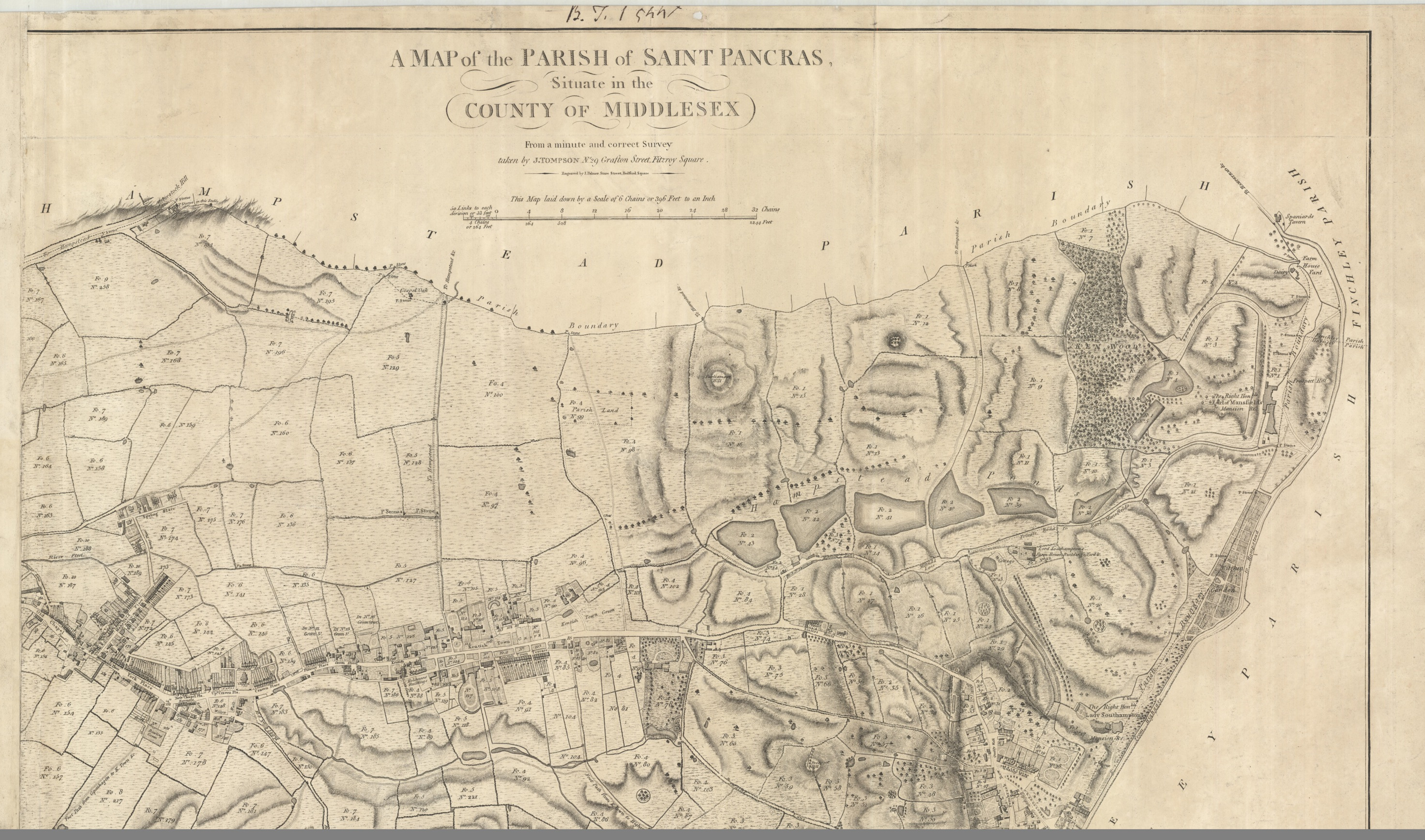
The map is on 2 sheets oriented with west (approximately) at the top. Although north orientation was fairly standard by 1804, it’s not unusual for large scale local maps to be oriented in whichever way most conveniently fits the shape of the paper. The southern extremity of the parish is the junction between Tottenham Court Road and Oxford Street (now the site of Tottenham Court Road tube station) in the west, and Clerkenwell in the east. The streets of Bloomsbury are already densely built up but north of what is now Euston Road is mainly open fields. Camden and Kentish town are separate villages on the main road out of London. The canal, of course, was yet to come and the mainline railway stations that dominate the area now were far in the future. The extract below shows the area now occupied by St Pancras and Kings Cross stations, and the British Library; the main road running from top to bottom is now the Euston Road.

It’s also interesting to see the things that remain, or have left tangible traces. The Polygon, a then recent development of houses in a circle facing inwards, was fairly recently built when this map was made; its name survives in Polygon Road nowadays. The Royal Veterinary College to the east of Camden was already established and is still there. On the northern sheet, the more hilly landscape towards Hampstead and Highgate is represented by hachuring; the distinctive shape of the line of ponds across Hampstead Heath hasn’t changed much since 1804. Kenwood House, then the seat of the Earl of Mansfield and recently remodelled, still stands surrounded by its parkland, now managed by English Heritage. The oak tree under which people would gather to hear gospel readings is marked; Gospel Oak is still the name of a London district and a train station.

The map is very detailed and finely engraved; the accompanying written survey, or terrier book, explains that the mapmaker, John Tompson (also described elsewhere as Thompson or Tomson) had made it under the patronage of landowners who had property in the parish, “at the expence of upwards of three years labour.” The terrier is very thorough, listing the landowners, and identifying the individual land parcels (numbered on the map) by their use and area. All individual streets are described and their buildings listed. This is an exceptionally detailed record of an area now transformed almost beyond recognition.