
In an already crowded field this has to be one of the more over the top cartouches.
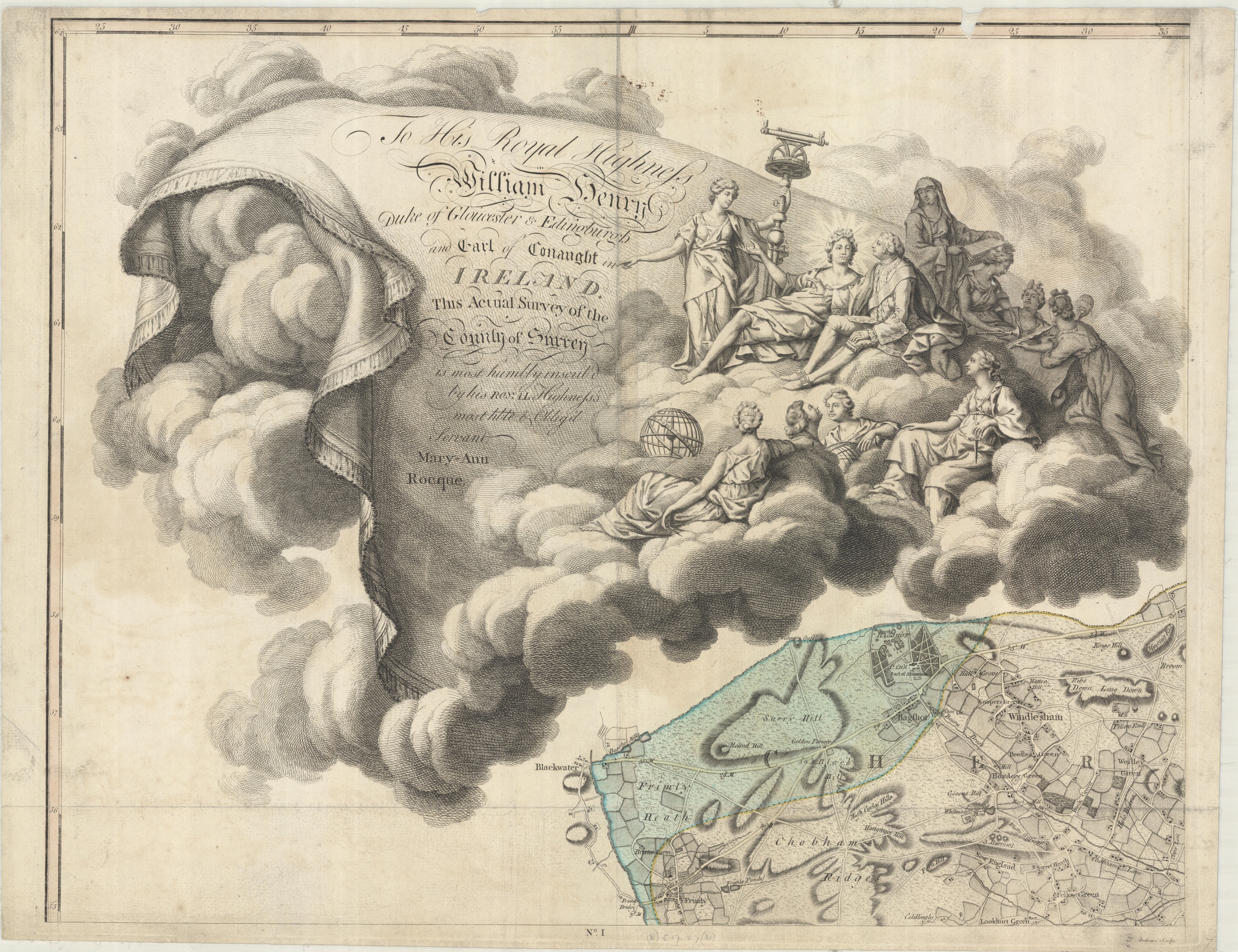
A cartouche is a decorative part of the map that contains information such as the title, cartographer and other relevant text, and often uses symbolism to portray a meaning rooted in Renaissance thinking. It can also, in the case of this map, include a dedication to a person who is either the patron to the map-maker or subscriber to the map being made, the original crowd-funding. Here’s a guide to what is actually going on with this map of Surrey, dedicated to His Royal Highness William Henry.

Prince William Henry, Duke of Gloucester and Edinburgh (1), grandson to King George II and brother to King George III, is surrounded by the the Nine Muses of Greek mythology, and with Geography, an additional Muse introduced during the Renaissance. The Muses are symbols for knowledge and the arts, and by portraying them and the Prince together the inference is that the Prince, and by association the map-makers, both deserve to be included in such lofty company. Amongst the Muses are Clio, who represents history and is usually shown with a book or a scroll and often a lyre (2), Melpomene, the Muse of Tragedy (3) holding a dagger, Urania, associated with astronomy, usually shown with a globe, compass or armillary sphere (4) and, appropriately, Geography, shown with a telescope and other surveying tools (5). The Muses to the left of Prince William Henry draw his attention to lavish praise given in the cartouche. Amongst this wealth of decoration is something that is easily over-looked but is as important at the time the map was made and now. Because of the lack of female cartographers Mary Ann Rocque deserves her place in the clouds (6). The title of the map is ‘A topographical map of the county of Surrey, in which is expressed all the roads, lanes, churches… the principal observations by the late John Rocque… compleated and engrav’d by Peter Andrews’ and this is the third edition, from c1775. John Rocque died in 1762 and his wife Mary Ann carried on publishing maps after his death. Even though Rocque surveyed Surrey in preparation for this map it was Mary Ann who was responsible for the printing and selling of the work and it is Mary Ann, ‘his most h[um]ble and oblig’d servant’ who dedicates the map to the Prince. Mary Ann went on to make maps herself, eventually being awarded the title ‘Topographer to HRH the Duke of Gloucester’.
The skill involved in engraving the cartouche is apparent throughout the beautifully coloured map. This extract of the Horsell area shows off the skill involved in engraving such fine detail.

This is the only map that John Rocque and Peter Andrews worked on together though Andrews did further work for Mary Ann Rocque before concentrating on nautical charts. The two different colours on this extract are for separate Hundreds, a county division larger that a Parish. For different reasons Horsell features in an earlier blog post here
A topographical map of the county of Surrey, in which is expressed all the roads, lanes, churches… the principal observations by the late John Rocque… compleated and engrav’d by Peter Andrews. c1775 (E) C17:57 (31)