
The easiest way to get round the age-old problem of portraying a three dimensional landscape on a flat piece of paper? Make a map that in itself is three dimensional. Freed from traditional European conventions dating back to Ptolemy peoples from different cultures could, and did, express themselves and their surroundings in a way alien to those with a ‘European mindset’ that made sense to those with a shared culture. Examples are numerous, ranging from the stick charts made by Polynesian navigators to the Medicine Wheels of North America, which enabled their builders to predict seasonal changes by astronomical observations (European prehistoric stone circles had a similar function). It is this freedom that enables the cartographer to use what ever material is suitable, as the Inuit hunter Kuniit has done with these maps made from wood, an ideal medium to portray a rocky and indented coastline.
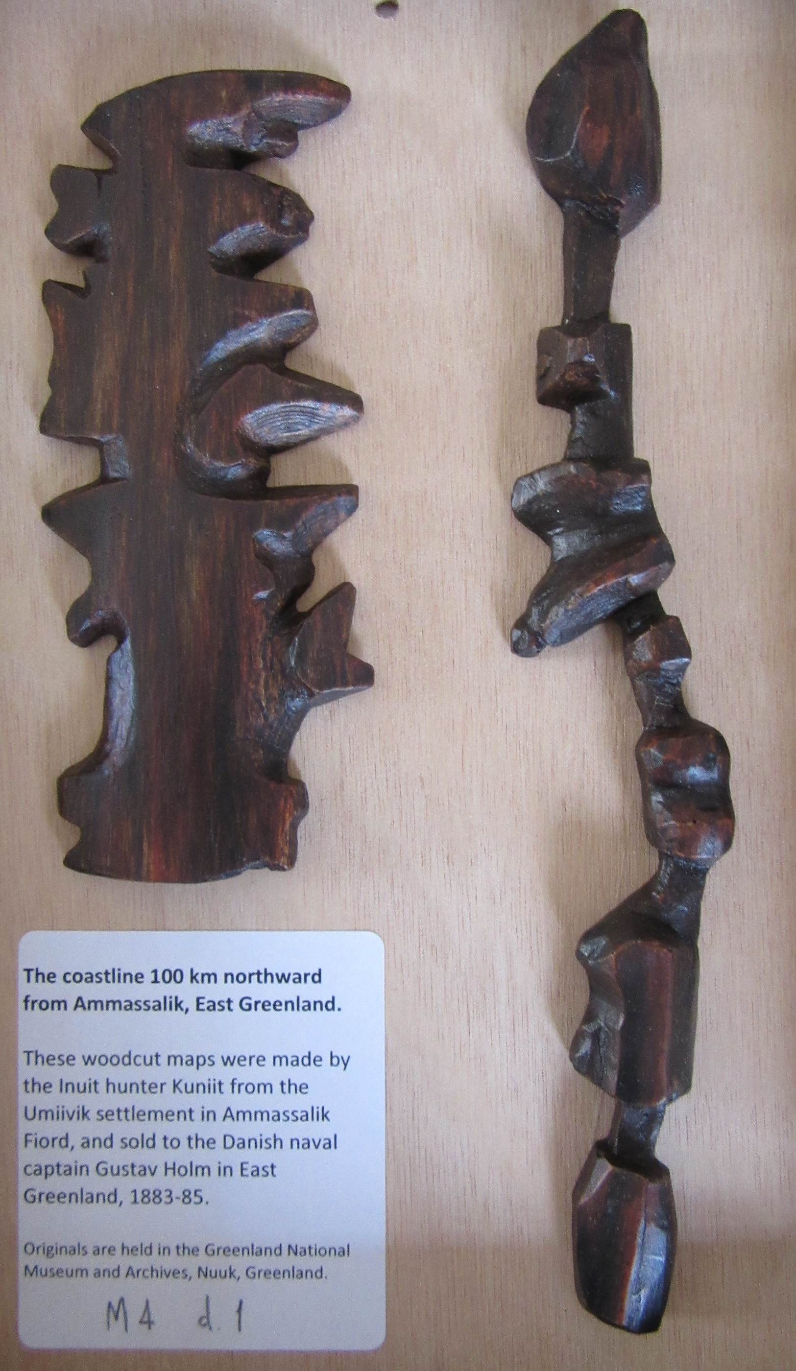 The maps were made in a settlement on Greenland’s eastern seaboard, Ammassalik, by Kuniit, who sold them to the Danish Naval Officer and Arctic explorer Gustav Holm during Holm’s expedition to south-eastern Greenland using traditional Inuit boats between 1883 and 1885. The originals are in the Greenland National Museum and Archives, these are facsimiles made for the 23rd International Conference of the History of Cartography, held in Copenhagen in 2009.
 At first these two maps appear hard to interpret, but a little bit of reading sheds some light. The surrounding coastline is a jumble of Fjords and off-shore islands, and it is this area north of Ammassalik that the two pieces map. The broader of the two shows the coastline while the longer the off-shore islands. Small nodules mark the places, according to Holm’s interpretation, where old settlements were sited and which proved good places to land a boat while the grooves over the ridges (shown here) show places where kayaks and small boats could be portaged around headlands when the seas were blocked by ice.
One of the more interesting aspects about the maps is how they portray the coastline, because the wooden blocks mirror the way the coastline wraps around the land. When used to journey around the inlets and islands north of Ammassalik the blocks would be continually turned to face the direction of the land shown on the blocks, north being very much a moveable concept. Also, the top features on both sides of the broader piece represent areas furthest away from each other on the map, as you drop down the wooden block, on both sides, the locations get closer together. Compare the blocks to the maps of the area, shown here, in this extract from Fishing chart of Southern Greenland & adjacent seas, 1906. M4:7 (1)


The top part of the thinner of the two wooden maps corresponds to Storö (a) on the paper map. As you drop down the wooden map the features match up with the paper as if you were sailing around them, so for insistence the penultimate island on the wooden map matches up with the island Morene (to the left of b) on the paper, so despite starting at the top with a northern orientation you now need to rotate the wooden block to face south to get it to match up with the coastline of Morene.
The same principles work with the larger wooden block. The top right corresponds with the northern side of the inlet above Storö (1), with the first inlet on the wooden block representing the small fjord above Storö (2). The right-hand side carries on down the coastline, ending up with the last section matching the small peninsula above the island of Stenö. Then the left-side of the larger block starts at the far extreme of the wooden blocks range, with the top sections representing the headlands above the settlement of Sermiligaaq (4) before ending opposite Morene (5). As can be seen there is a natural flow to the wooden blocks in harmony with the land they map. A fluid approach to orientation allows for a design that is as uncomplicated as possible, despite first appearances.

The question is though how useful this would be to the Inuits of the area. To be be able to map an area so well would suggest that for your own use you wouldn’t need to map it in the first place. So were these blocks made as a navigational aid for Holm, who presumably had existing maps and charts of the area already, or with the onset of European exploration in the region were they made to sell, as souvenirs in much the same way that the majority of the Polynesian stick charts that exist today were made towards the end of the nineteenth century for European explorers?
Gustav Holm wrote a number of articles in the Danish journal ‘Meddelelser om Grønland’ (Notices of Greenland) about his travels around King Christian IX Land, which were illustrated with a number of sketches, photographs and a map. One of the sketches is of the wooden blocks, where it can be seen that there was a third made, which covers the area around Ammassalik between the fjords Sermiligaaq (Sermiligak on the map, top right) and Kangerdlwarsikajik (Kangerdluarsikajik on the map). Identifying places isn’t easy as spelling isn’t consistent across available maps, with places even spelt in slightly different ways between the text and the maps in Holm’s articles!
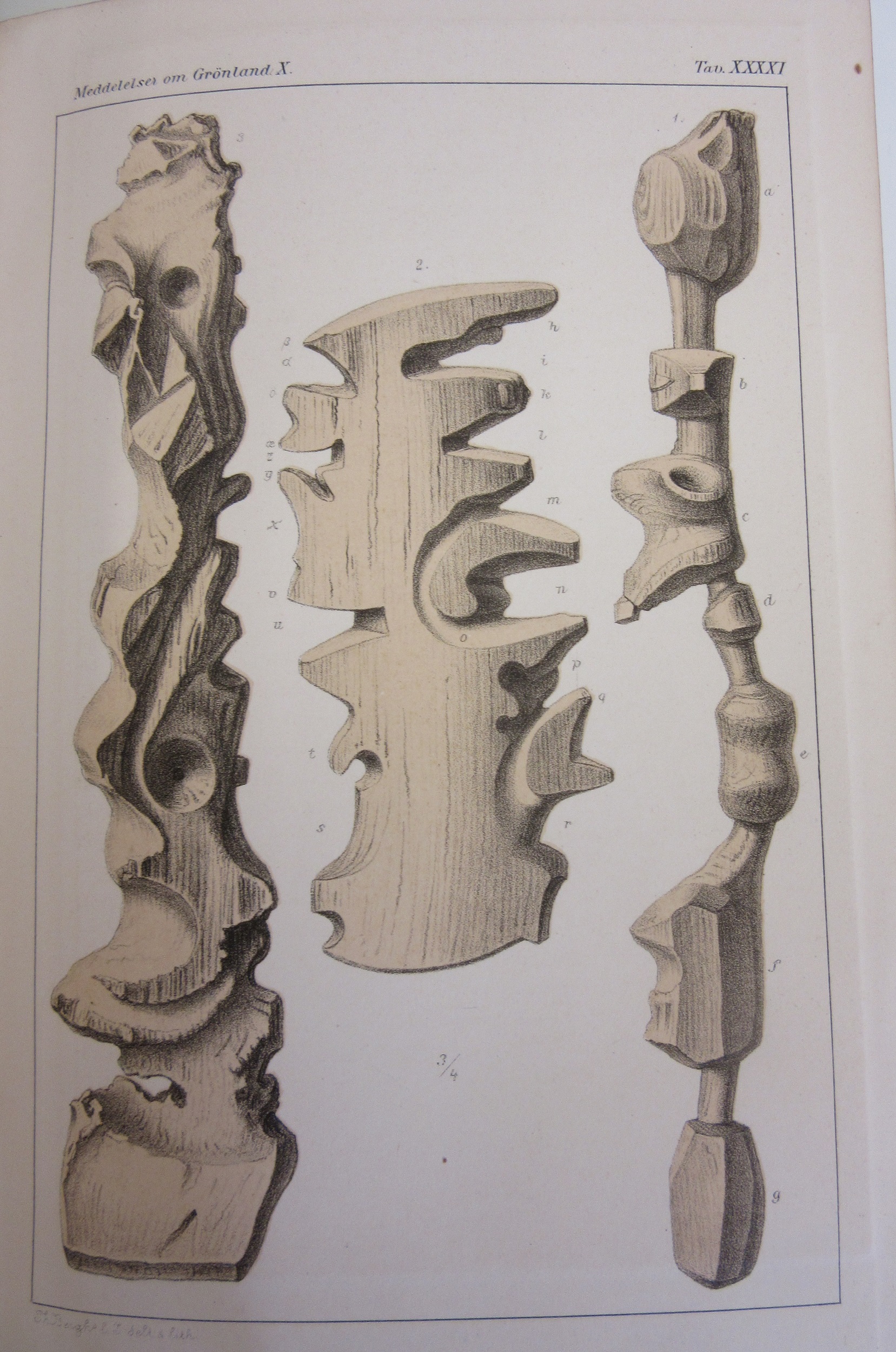
As can be seen in these sketches of the three wooden blocks the two blocks that were reproduced for the 2009 Conference have numerous references next to key points which correspond with a page of text next to the image. The image on the left doesn’t have these, and in the text is given the briefest of mentions (‘Fig. 3 represents the halfway between the fjords Sermiligaaq and Kangerdlwarsikajik’) which suggests that when It was given to Holm it was either too old or too inaccurate to be of use. It certainly doesn’t have the sense of newness that the middle and right-hand maps have.

This map and image of the wooden blocks come from ‘Meddelelser om Grønland’, 1888. Gen. Per 22
Information on the maps came from the The History of Cartography, vol. 2, book 3, Cartography in the traditional African, American, Arctic, Australian and Pacific Societies, edited by David Woodward and G. Malcolm Lewis,1998 G24 B1.100 (2iii)
The coastline 100 km northward from Ammassalik, East Greenland made by the Inuit hunter Kuniit from the Umiviik settlement in Ammassalik Fiord, 2009 M4 d.1