
The end of January marks the eightieth anniversary of the end of the Battle of Stalingrad, generally regarded amongst military historians as the turning point of the Second World War. German troops in the city surrendered on January 31st, with the encircled troops to the north following on a few days later. For Germany Stalingrad was meant to be a quick battle, a way of cutting off the Volga River supply route before the main objective of the Caucasus oilfields. Instead vicious street fighting bogged down an already extended army, forcing them into another Russian winter.
In preparation for the invasion of Russia in June 1941 the German army produced a large amount of mapping. Most of the topographic at 1:50,000, 1:100,000 and 1:200,000 was based on pre-existing Russian maps but the Germans also produced a large amount of small scale mapping, including thematic maps, to help plan the invasion. Examples here show both the range of maps made and the logistical issues involved in invading a country which had, in the countryside at least, poor transport in place and a winter that could be brutal. Due to the large size of the maps shown here these extracts centre on Stalingrad.
Wehrgeologische Übersichtskarte des Europäischen Russlands, 1941. C40:6 (163)
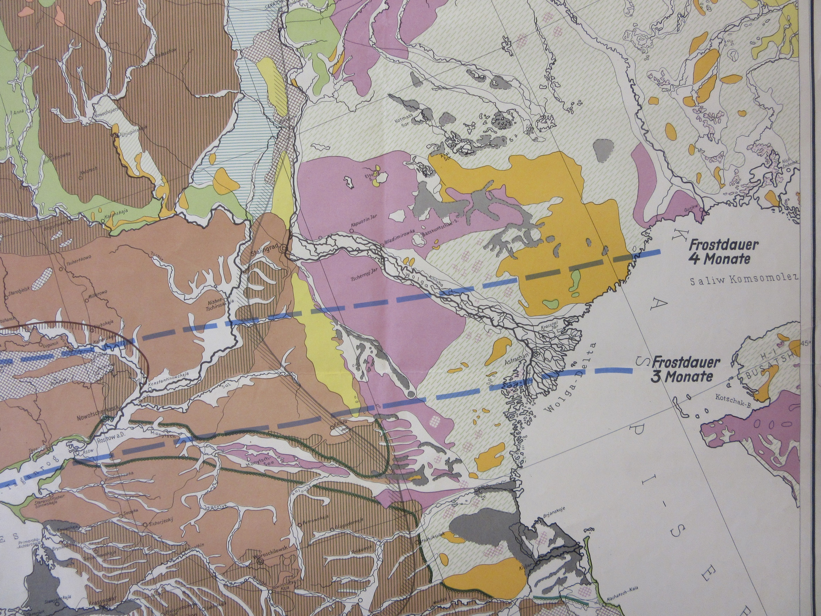
This extract from a much larger map shows the geological conditions around Stalingrad (which is just north-east of centre, on the bend of the river). The brown indicates a loess soil structure, which makes for finely grained soil. Good for agriculture but not much good for transport or water retention, something which the legend on the map states, ‘wasserversorgung schwierig’ (‘water supply difficult). The map also shows something else that was going to be a major problem for the German troops fighting in the area. The dotted blue lines show areas of frost by months. Stalingrad falls into the zone where there was on average four months of frost which, with extended supply lines and lack of winter-clothing, led to German troops fighting in freezing conditions without appropriate winter gear, many suffering from frostbite and other aliments as a result.
Strassenzustandskarte der besetzten Ostgebiete, 1942. C40:6 (50)
From another large map comes this extract showing the road set-up around Stalingrad. This shows on the surface what the geological map hints at, the dotted red lines of so many of the roads around the Stalingrad area are graded ‘Ungeeignet, d.h. für Mot. Verkehr nicht geeignet’ (‘Unsuitable, i.e. not suitable for motor traffic’) while the lack of knowledge of the area (the map dates from August 1942, when the battle for the city started, and would partly be based on earlier Soviet maps) is shown by the continuous red-lined roads being labelled with a general description of ‘good’. There’s also this text box…

… which asks for the ‘Cooperation of all required! (Mitarbeit…)’ going on to request that any changes in road condition be reported immediately, a hint to the boggy nature of loess ground when the rains come.
And then there are the general topographic maps made by the cartographic branch of the army. Maps such as this example at various scales cover the whole of Europe, most of North Africa and the Middle East. Usually based on pre-existing national sets (the British maps are adapted versions of earlier Ordnance Survey commercial maps) these are often highly detailed and, with added text and town plans on the reverse, specialising in the area shown. Sheet D49 of ‘Mil.- Geo.- Karte Östeuropa 1:300 000′ (1942, C40 (72a)) covers Stalingrad.

The city is shown with a black box surrounding it indicating that there’s a town plan on the verso. Text on the side covers topics such as soil, structure, hydrology, climate (‘winter short, but very cold’) , transport and population. As an example of the confidence the army had in a quick victory at Stalingrad the map also lists 8 locations east of the Volga, beyond the city, to take as well.
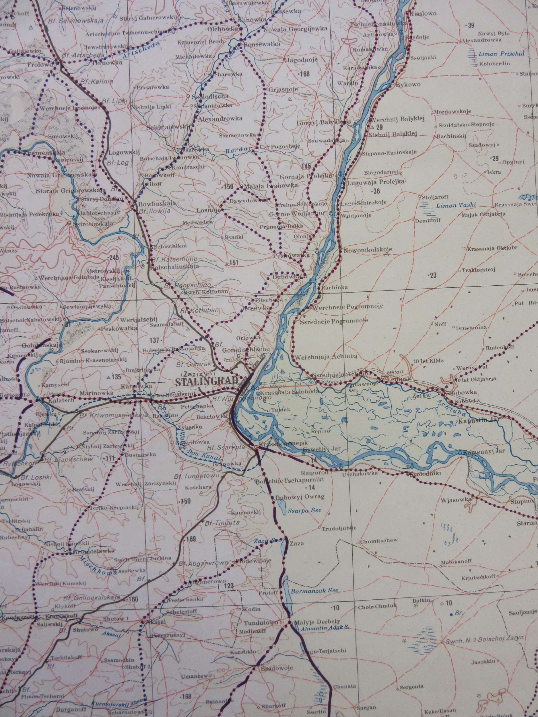
Finally, the city itself. This is the city plan from the back of the 1:300,000 sheet, again this features text on the city (population – 445,470 as of 1939 – etc) and a list of objectives.
 The city stretches out along the west bank of the Volga, making the key features an easy target for the German artillery that surrounded it and the bombing raids by the Luftwaffe. Vastly outnumbered soon Soviet troops were occupying the factory area to the north of the map (nos. 31-39) the station area (Bhf. just below no. 40) and the important low hill of Mamayev, fought over and won and lost continually throughout the battle (shown by the spot height 100. west of nu.39 and now the site of the ‘Heroes of the Battle of Stalingrad’ memorial).
As well as the large amount of single and series sheet maps produced the cartographic branch of the army (the ‘Abteilung für Kriegskarten und Vermessungswesen’) produced large numbers of information pamphlets for various countries. The earliest were made out of hard board but as more and more were produced brown paper packages were created. These included maps, books on locations and features (duplicating a lot of the information shown on some of the maps here) and photographs. Here’s the pamphlet package for the area covering Stalingrad

Miltärgeographische Angaben über des Europäische Russland, Die Wolgagebiete, 1941 C40 e1/K
And here are two images from the book of photographs, the first showing the central square and the second the tractor factory (no. 31 on the town map extract above), sight of some of the heaviest fighting throughout the battle for the city


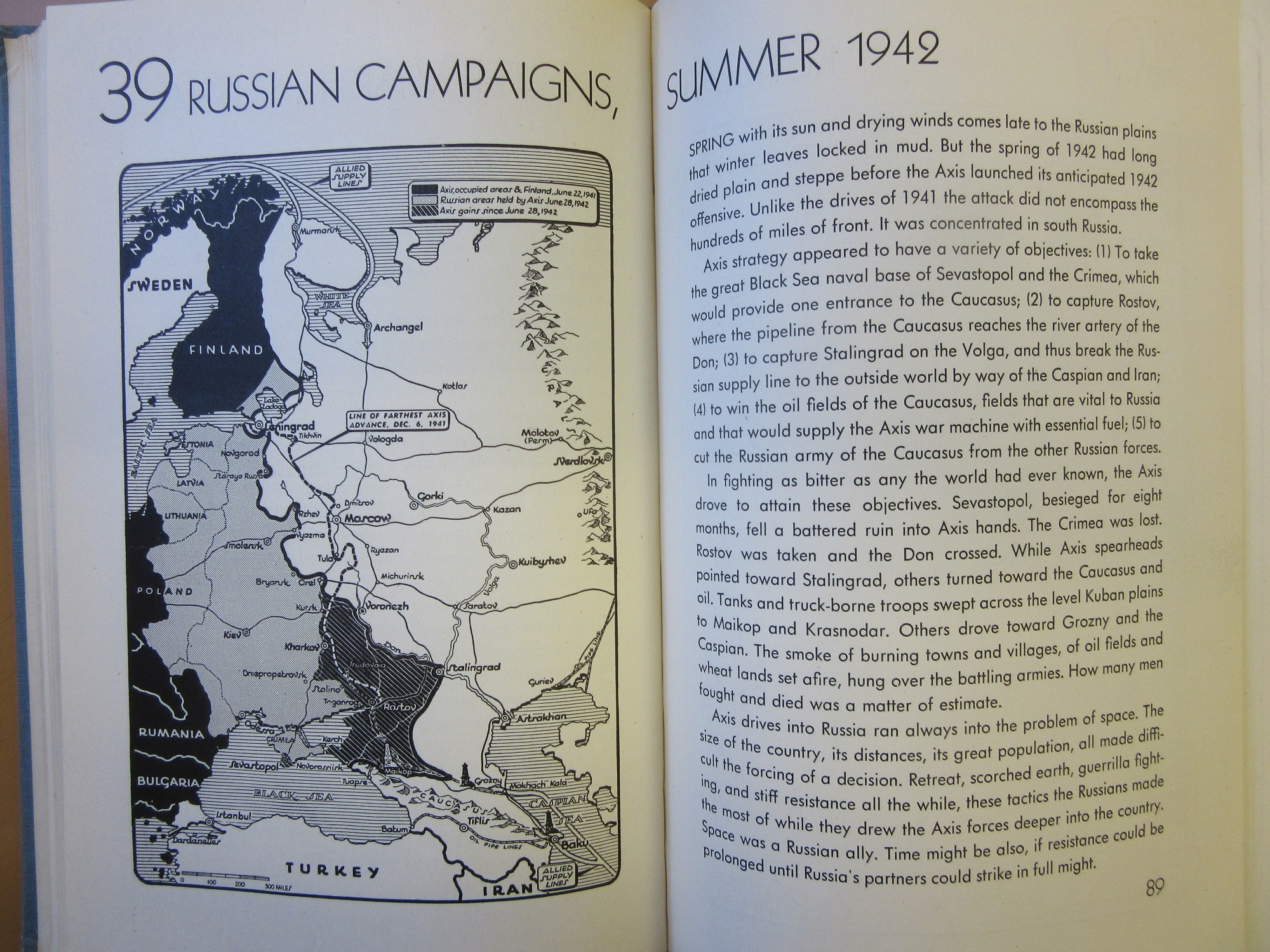
 In contrast to these military maps is a series of maps published in an atlas by the New York Times during the war (2023 d.39). These maps show a history of the war from its origins in treaties after the First World War up to publication of this, the second revised edition in 1943. While German forces were in retreat in the East Western Europe was still firmly in control of the Axis powers and the outcome in the war was still in doubt. Typical of the sort of maps that were common in newspapers during the war here are two maps from the atlas, with an extract from the first at right, covering the Russian campaign before and after Stalingrad (a short blog about maps in newspapers can be found here ).

Last word (and map) to the victors. On a large map covering four sheets the ‘Great Patriotic War of the Soviet Union’ (1956, C40 (427)) shows the advances, retreats and battlegrounds between the German Invasion in 1941 to the end of the war in Berlin in May 1945. Around Stalingrad the thick orange and red tipped arrows can be seen that show how the Soviet advance, codenamed Operation Uranus, encircled and then cut off supplies to the Axis forces (Italian and Romanian divisions also fought at Stalingrad), eventually forcing those trapped to surrender.
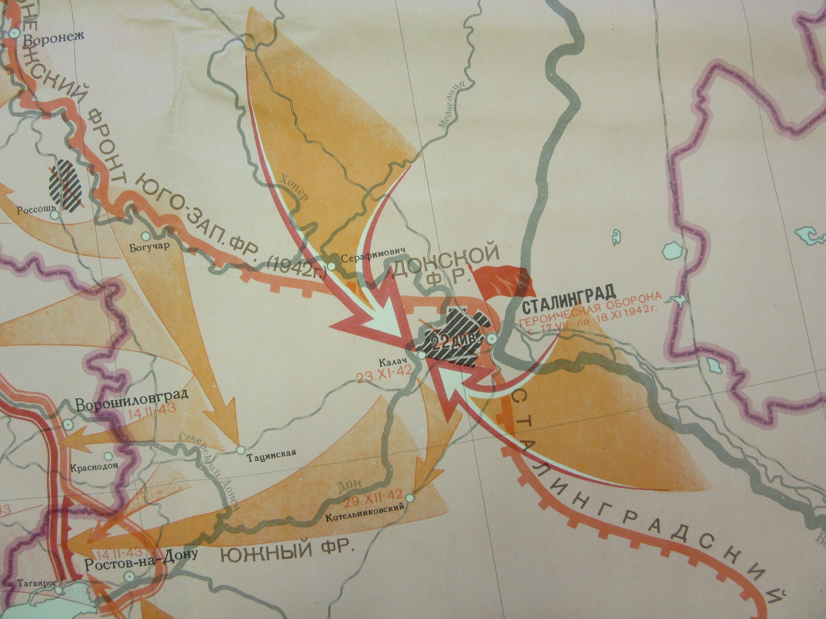
The map was published in 1952 by the Glavnoe Upravlenie Geodezii i Kartografii, the official cartographic department for the Soviet Union, and known more commonly by the initials GUGK.
A blog on the changing names of the city on the Volga can be found here
