Category Archives: Humour

A horse?

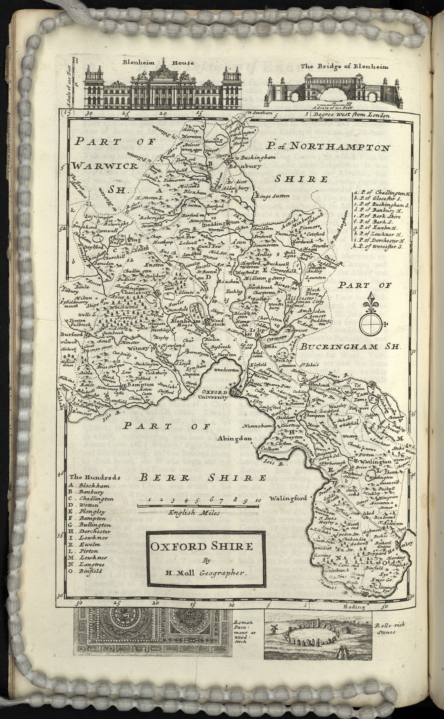
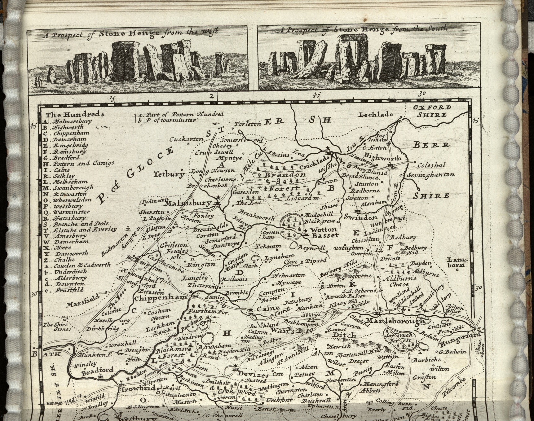
Chalk figures on hillsides are not uncommon especially in southern Britain but they still retain the air of mystery. What are some of them?  Who created them? Why are they there? They also caused an issue on maps.  Early modern cartographers drew maps but out of necessity gathered information from other surveyors. This is where errors crept in.  Imagine an surveyor of the Berkshire Downs at Uffington saying “well, there’s this white horse on the side of the hill”.  The prehistoric ‘horse’ famously does not look like a horse therefore the misunderstandings can be seen as a result, most notably the Sheldon tapestry map of Oxfordshire which has a truly majestic (and enormous) white horse striding over the side of the hill.


Richard Hyckes who designed the tapestry was not to know the reality was rather different.


The error was repeated by John Rocque albeit with a more modest horse.


It wasn’t until the Ordnance Survey surveyed the country was the Uffington White Horse depicted as it truly is.


The Cerne Abbas Giant is actually a giant cut into the chalk of Dorset, rather a famous one. He is  younger than the horse but his beginnings are still shrouded in mystery but possibly something to do with former Cerne Abbey nearby. For some reason he was only represented as lettering by Isaac Taylor 1765.

However, the Ordnance Survey somewhat sanitised him when the 25” was published in 1888.

The Long Man of Wilmington in East Sussex was not so problematic, so much so that he didn’t appear at all until the OS came along. The map by Thomas Yeakell and William Gardner (1778-1783)  ignores him completely – whether they were unaware of the chalk figure or merely swerved the opportunity of representing it history does not tell us.


Sheldon tapestry map of Oxfordshire  [1590?] (R) Gough Maps 261

John Rocque. A topographical map of the county of Berks (1761) Gough Maps Berkshire 6

Ordnance Survey 2nd edition 1:2500 Berkshire XIII.14 1899

Isaac Taylor. Dorset-shire. 1765 Gough Maps Dorset 11

Ordnance Survey 1st edition 1:2500 Dorset XXXI.2 1888

Thomas Yeakell, William Gardner. The county of Sussex. 1778-1783. Gough Maps Sussex 14

Ordnance Survey 3rd edition 1:2500 Sussex LXVIII.15 1909

A very dark Dark Ages

The Ordnance Survey are justifiably famous for the Explorer and Landranger maps that guide us on so many walks and journeys.  They have also, for the last 100 years, produced specially themed historic mapping. The first was a map of Roman Britain in 1924, soon followed by maps of XVII Century Britain and the one featured in this blog, Britain in the Dark Ages. All the maps had text attached and all featured beautiful covers designed and drawn by Ellis Martin, an artist working for the Ordnance Survey who has featured a number of times on our blogs (here, and here)

The library has acquired some old pre-publication material from the Ordnance Survey via a recent donation of maps. Along with some surveyor drawings there are a number of early attempts in design for these historical maps, most show markings where errors have been made but this early attempt at the Dark Ages map took us by surprise. It isn’t hard to see why this was rejected and a whole new design sold to the public instead.

Dedicated with great disrespect and contempt…

In a collection that has it’s fair share of strange maps (‘Naughty Norman’s London sex map’ anyone?) this has to be one of the strangest.

A new & exact map of Toryland, with the dangerous rocks & shoals of all the Jacobite Islands lying in the same parralell with the Red Sea, whose lattitude is 1588 & longitude 1714. Dedicated with great disrespect & contempt to the Knight of ye Warming Pan & King of No-Land ye Pretender & all his Brainless adherents’. 

Where to start? The Knight of the Warming Pan was James Francis Edward Stuart, the Old Prentender, the son of the last Catholic King of England, James II. His mother, Mary of Modena was considered past child-bearing age (a stately 29 at the time of the birth) so it was suspected that a baby had been smuggled into the bedchamber in a warming pan, in an attempt to keep a Catholic succession in place. 1588 is the date of the Spanish Armada while in 1714 George Louis, a Lutheran Prince from Hannover in Germany who was the closest relative to the recently deceased Queen Anne became George I. The fact that the crown was now in the hands of a foreign national who didn’t speak English didn’t go down well with James, who would have been King if his father hadn’t been deposed during the ‘Glorious Revolution’ of 1688, restoring Protestant rule with William III, William of Orange as was.

The Jacobite Rebellions were attempts in the Seventeenth and Eighteenth Centuries to restore the House of Stuart to the throne. This map is a cartoon satire against that, the ‘dangerous rocks and shoals’ that surround Toryland are symbolical of the dangers that sailors face when navigating around dangerous shores while Toryland itself is full of warnings about what a Catholic monarchy would mean; ‘Restoration of Abby land’ (as in a return to the Abbeys and Monastery’s in place, and all the supposed corruption and indulgencies associated with them from before the Reformation), the Bishoprick of Rome, arbitrary government and absolute monarchy amongst others. The islands and shoals surrounding are also full of danger; No parliaments, loss of trade and no juries featuring here amongst others, as well as the island of ‘D-m me I’m in high church, & ye Presbyterians are Sons of Whores’.

Nearly off the map is Whig Island, a land of Protestant and English  tradition. Here we find safety in ‘Magna Charta’ land, ‘Parliamentary Right’ and ‘Hannover Succession Rock’.

Like all maps trying to make a serious point this works because it looks like, and uses, standard mapping practise. The compass rose is an example. Traditionally used to show the compass directions in this case the compass points to people prominent in the Jacobite movement.

The compass also has a dual meaning. In mapping terms it shows direction, shows the right and wrong way to go, and this can be compared to a moral compass, which has the same purpose, to show the right and wrong way to live your life. Other stock mapping traditions can be seen in the way that rocks and dangers are portrayed, the use of crosses is both common on nautical charts of the day to show rocks but also has religious overtones while the language in the title is similar to that of other maps, ‘Great disrespect and contempt’ mirroring the dedications on many maps to rich and influential people (see here for example)

There are a number of variations of maps making a point by pretending to be a serious cartographic work, a blog about a religious example can be found here, while political versions can be found here. These ‘imaginary maps’ have a long cartographic tradition, and can be seen to have their origins in the maps painted on the walls of Egyptian Tombs to show the departed souls the way to the underworld and continue with Thomas More’s map of Utopia through to the cartoon maps linked above to famous recent examples such as the classic Guardian April Fools from 1977 April fool – San Serriffe: teaching resource of the month from the GNM Archive, April 2012 | The Guardian Foundation | The Guardian

fol. Delta 755

A map of the most beautiful place in the World (perhaps)

The Lake District is one of the most beautiful areas in the country. Don’t just take my word for it, take Peter Crosthwaite’s. This map, created by Crosthwaite, is titled ‘An acurate map of the matchless lake of Derwent (situate in the most delightful Vale which perhaps ever human eye beheld) near Keswick, Cumberland…’  Considering that Crosthwaite alludes to himself as ‘Admiral to the Keswick Regatta, Keeper of the museum at Keswick, guide, geographer and hydrographer to the nobility and gentry who make the tour of the Lakes’ he obviously wasn’t one for modesty.

The map itself doesn’t quite match the beauty of the location but it does include a lot of useful information; spot depths in the lake and travel and tourist information. As with most maps of the time Gentlemen in the area are named and the major houses in the area are portrayed. Crosthwaithe made maps of other lakes, including Windermere (shown here) and Coniston. While neither have such flowery titles both have poems extolling the landscape shown.

All the maps feature ‘West’s stations’, viewpoints mentioned in one of the earliest guides written about the area, Thomas West’s ‘A guide to the Lakes: : dedicated to the lovers of landscape studies, and to all who have visited, or intend to visit the lakes in Cumberland, Westmorland, and Lancashire’. West and Crosthwaite were promoting the Lake District at a time when tourism to the area began to grow.

Many cartographers make bold claims with their maps, with titles including such phrases as ‘an exact survey’, ‘new and improved’ and ‘drawn from the best authorities’. These maps flip that convention around by putting the praise back where it belongs, the countryside.

An accurate map of the matchless Lake of Derwent (situate in the most delightful vale which perhaps ever human eye beheld) near Keswick, Cumberland; with West’s seven stations 1784. (E) C17:22 (9)

Dog-eared

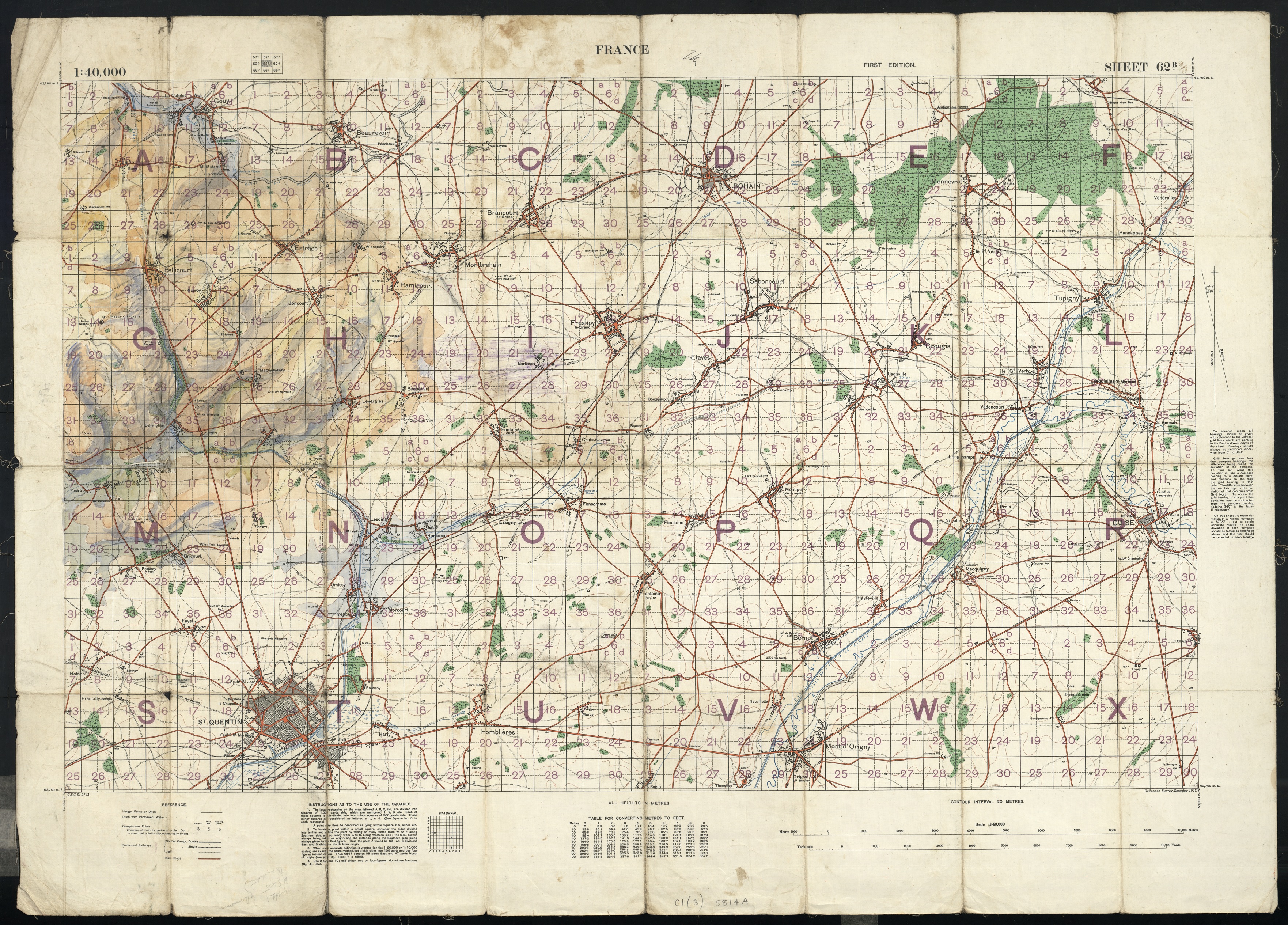
We all have maps like this. Dog-eared, well used, creased, pushed into pockets or bashed about in a rucksack. For whatever reason they show signs of wear and tear, which is an inevitable outcome considering the purpose of Ordnance Survey Landrangers and Explorers in the first place. Every crease or mark is a souvenir of a good walk or cycle.
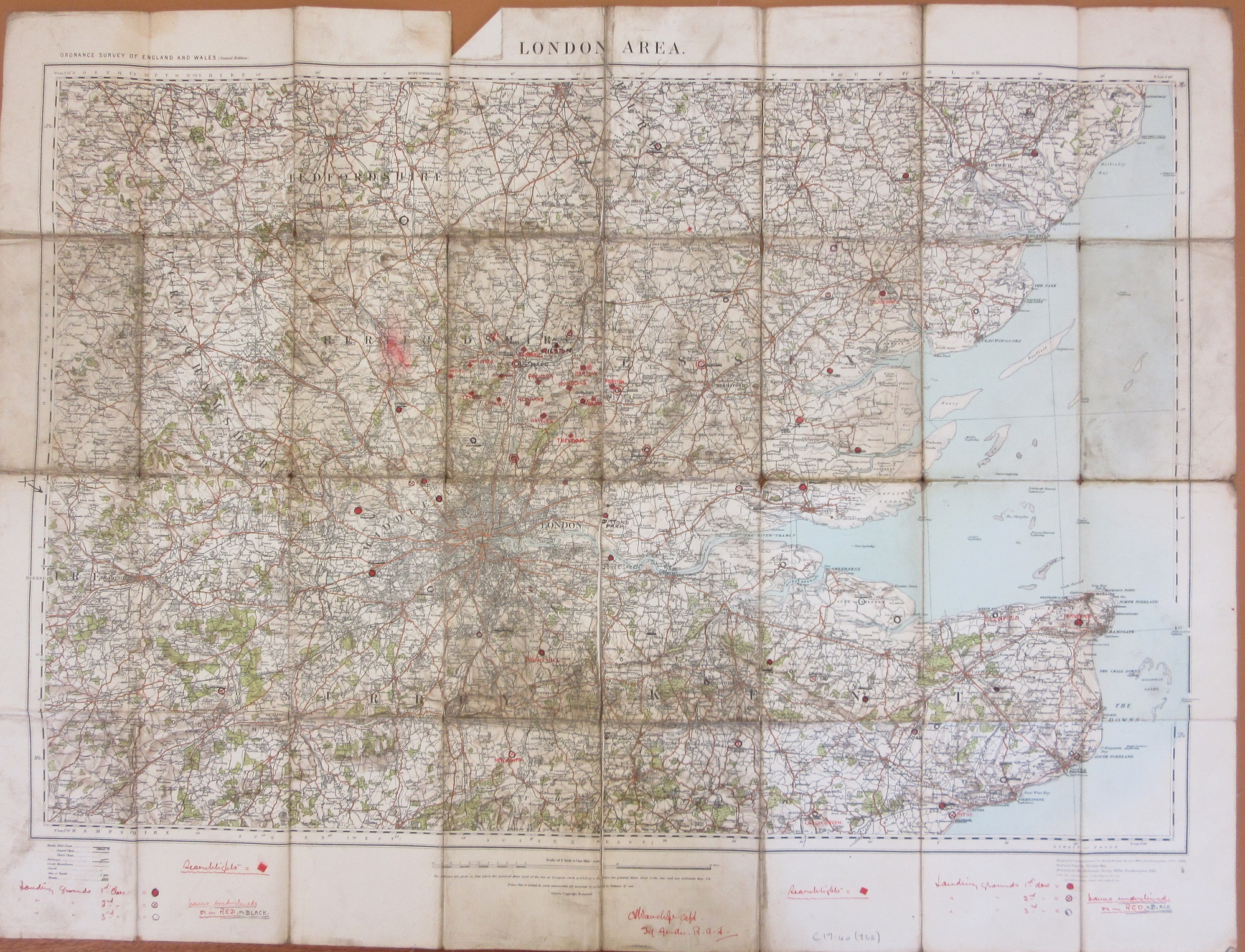
This map, Landranger 194, Dorchester, Weymouth & surrounding area, from 1989 went on an early walking holiday with the future wife, in the early 90s. We took her dog Tess with us, an intelligent Labrador with a sense of fun. On one walk the map was spread out on the grass to plot the route and Tess walked across it. Tess is long-gone, but her paw print is still there, over Winterbourne Abbas and its stone circle, the Nine Stones. The map may have been superseded, but the personal importance will never go out of date.

We all have maps like this, don’t we? We have in the collections at the Bodleian. It’s exciting to come across a map that has been changed in someway, often to suit the owners’ needs. War seems often to be a cause, be it an altered trench map to show terrain

or a commercial Ordnance Survey 1/4″ sheet with additional marks made by a First World War pilot marking safe landing grounds around London (more on this map can be found here)

Then there are the plain bizarre, these links will take you to earlier blog posts of an intriguing burn mark on a map made during the Revolutionary period in France (here) and a map used by the film director Michael Winner to plan scenes for a film set during the Rome Olympics (here), 

Wife and dog on Dorset walk. Note state of paws, those aren’t socks.

The Devil’s what?

Herman Moll (c1654-1732) was a cartographer  who moved to London from north-west Europe in 1678. At first Moll worked for other established mapmakers as an engraver before setting up his own workshop making and selling maps. These images come from one of his most celebrated works, ‘A set of fifty new and correct maps of England and Wales’* published in 1724. The Bodleian has a number of copies of this work, some of which were in black and white with others hand-painted, these images come from one of the black and white editions.

Oxfordshire has two illustrations for Blenheim Palace, completed two years earlier in 1722, and one for the Rolle-Rich Stones (Rollright Stones), built considerably earlier at some point  between 2670 to 1975 BC. For those familiar with the Rollrights this is an image before restoration in the late 1800s which replaced a lot of stones broken up from the original circle, increasing the amount of stones in place. Next to the Rollrights is a mosaic from a Roman villa north of Woodstock.

One of the stranger illustrations found on any of the county maps is from the the West Riding of Yorkshire page, of the Halifax gibbet, which promises ‘according to the Halifax Law whereby they beheaded any one instantly‘. A ruling (the ‘Halifax Law’) that allowed the Lord of the Manor to execute thieves by beheading had been in place since the 1200s, and the gibbet was Installed at some point in the sixteenth century. A large number were executed under this law but it isn’t known how many were executed using the gibbet, which was dismantled after the the last executions in 1650 under instruction from Oliver Cromwell.

Moll had an obvious love of anything old, his county maps are filled with portraits of antiquities around the margins, and on his title page a note promises ‘to render this work more acceptable to the curious, the margins of each map are adorn’d with great varieties of very remarkable antiquities’. Roman coins and fossils, given all sorts of weird and wonderful names, feature prominently. On this half page of Wiltshire two views of Stonehenge are given. Both are a relatively accurate portrayal, something that earlier cartographers such as John Speed, hadn’t done, setting the great circle in mountainous countryside and making the stones look tubular (extract from Wiltshire, John Speed, facsimile (E) C17:61 (49), original map 1610).


.

This last page is a map of the county of Derbyshire, parts of which have an underlying limestone bed, leading to numerous cave systems.

The Devil’s Arse is more commonly known now as Peak Cavern.

There is little in the maps in Moll’s book that make them any more special than similar atlases printed at the time. Few roads are shown, though those that do have distances between towns marked, and boundaries of the county hundreds are set out. What makes Moll special is the illustrations, historical portraits made to appeal to both the armchair traveller and any with an archaeological and scientific interest giving an idea of the unique features found in each of the counties.

*The full title is A set of fifty new and correct maps of the counties of England and Wales, &c. with the great roads and principal cross-roads, &c. Shewing the computed miles from town to town. A work long wanted, and very useful for all gentlemen that travel to any part of England. All, except two, composed and done by Herman Moll, geographer.

Allen 18

Happy Christmas

This image comes for sheet Oxfordshire L.3 of the first edition Ordnance Survey County Series maps of England and Wales at 1:2,500. It is of the wonderfully named Christmas Common, in the Chilterns.

There are a number of suggestions for the name, a possible truce at Christmas during the Civil War or for the number of Holly Tree coppices in the area though a local family called Christmas sounds the most likely.

There are 8 place names which begin with Christmas listed in the gazetteer for the Ordnance Survey 1:50,000 series, including the wonderful Christmaspie in Surrey (this image from the 3rd ed OS 1:2,500 sheet Surrey XXIII.13, 1910. Only the first edition was available in colour as well as black and white).

Happy Christmas everyone.

Christmas 2018

Two maps of Christmas Islands, the first off the coast of Java in the Indian ocean, the second in the Pacific Ocean and more commonly known as Kiritimati, which means Christmas in the Kiribati language.

Christmas Island, partly from a survey by C.W. Andrews, F.C.S…1899. L5:1 (3)

The Indian Ocean Christmas Island was discovered in 1615 and named Christmas Island in 1643 by William Mynors.

Christmas Island from a chart supplied by Pere Emmanuel Rougier in 1924…1939. J11:4 (1)

The Pacific Ocean version was discovered by Spanish explorers in 1537 but named by Capt. James Cook on the 24th December 1777. It is a raised coral atoll and part of the Republic of Kiribati.

And now for a quiz. This extract, from sheet 17 of the Gold Coast survey at 1:62,500, has one unusual feature. There is, of course, a chance that the hill is shaped this way, but seems likely the surveyor was having fun. Can you spot it? Answers, or help, to maps@bodleian.ox.ac.uk

Sheet 17, Gold Coast Survey, 1924, E34 (24)

Waste not, want not

The Conservation staff were checking the Duke Humfrey shelves for items for repair when they came across an unusual example of printed waste fragments used as pastedowns. This practice, born of economy as no bookbinder would wish to waste a clean sheet of parchment or paper when a surplus or damaged sheet would do, started early in printed book history as there examples of William Caxton’s work used this way but was especially common in the first half of the seventeenth century. What is more unusual is that it is cartographic waste. This example is of a John Speed work usually found in the King James Bible, Map of Canaan which he originally published in 1598. The endpapers are also blackletter printers’ waste. The volume contains two Latin texts: Philosophia theologiæ ancillans; hoc est, pia & sobria explicatio quæstionum philosophicarum in di sputationibus theologicis occurrentium by Robert Baron (1593?-1639) published in St Andrews in 1621 and De legatione evangelica ad Indos capessenda admonitio.  by Justus Heurnius published in Leiden in 1618.  Often interesting printer’s waste is not evident unless a volume is damaged.

The binding is full sprinkled calf with fillets on upper and lower boards with evidence that it once boasted ties.  What makes it recognisable as an Oxford binding is the two way hatching on board edges.  The shelfmark is 8° B 105 Art., written on the foredge, denotes that is comes from one part of the original Bodleian four-part classification which sorted texts by faculty or subject including mathematics, history, philosophy and literature.

.

The very best of Peter André?

Map makers can be people of many talents. The most famous example is John Ogilby, who had many varied careers including dancing master, Deputy Master of the King’s Revels in Ireland, theatre manager, soldier, translator and publisher before embarking on his final and most successful venture as a map maker in his sixties, and publishing the first road maps of Britain in 1675.
Readers may be surprised though to learn that Peter André, famous for his singing, dancing, reality TV career and Iceland television commercials, was also responsible for surveying Essex in the 1770s. His name appears on the cartouche below that of John Chapman, a London based map publisher who also carried out local and county surveys in Staffordshire and Nottinghamshire. It’s a detailed map, covering the whole county on 25 sheets at a scale of approximately 2 inches to the mile; a remarkably large scale for a map that pre-dates the Ordnance Survey.
There are a few clues in Andre’s musical work about his mapmaking abilities. His album ‘Come fly with me’ suggests an approach to surveying that was well ahead of its time. And of course ‘The long road home’ must have been familiar to many a surveyor after a hard day’s measuring in the field.
The lyrics of his biggest hit, ‘Mysterious Girl’, also include the lyrics
I stop and stare at you, walking on the shore,
I try to concentrate, my mind wants to explore …
Strongly suggesting that the surveyor was distracted from his work of exploring the Essex shoreline by the sight of a local beauty. Since this happened around 1774, her identity is likely to remain a mystery.

It’s a beautiful map, finely engraved and delicately coloured, of which its creators can be justifiably proud.

A map of the county of Essex from an actual survey taken … by John Chapman & Peter André. London : Chapman & André, 1777, and Colchester: Keymer, 1785. C17 a.4

April 1st, 2017