Category Archives: Uncategorized

Population maps

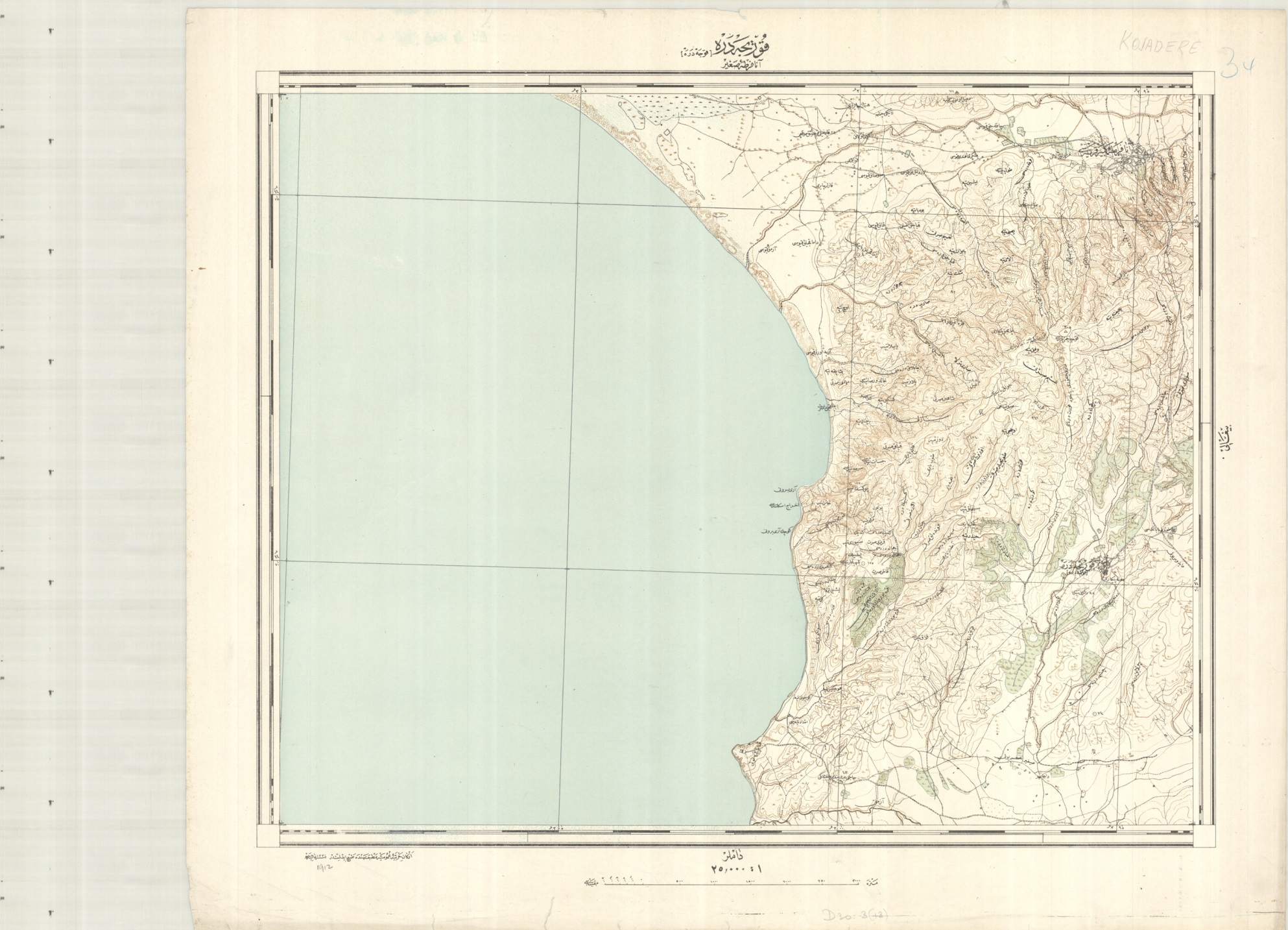
This population map of the Saxony region of Germany is a recent addition to the map collection. Volksdichte-Schichtenkarte des Königreiches Sachsen nach der Zählung vom 1. Dezember 1900 (Population density layers map of the Kingdom of Saxony after the census of December 1, 1900) shows density of population by colour with two insets for the areas around Dresden and Leipzig from an earlier 1846 census.

pop

Volksdichte-Schichtenkarte des Königreiches Sachsen nach der Zählung vom 1. Dezember 1900, C22:25 (74)

Population maps such as this are, in the field of cartography, a relatively recent product, with the first known examples being published in the early 1800s. Early maps would give tables showing population figures, this example from 1822 has one that is Christian only and colours parts of the World depending on the ‘Degrees of Civilization’.

clarks

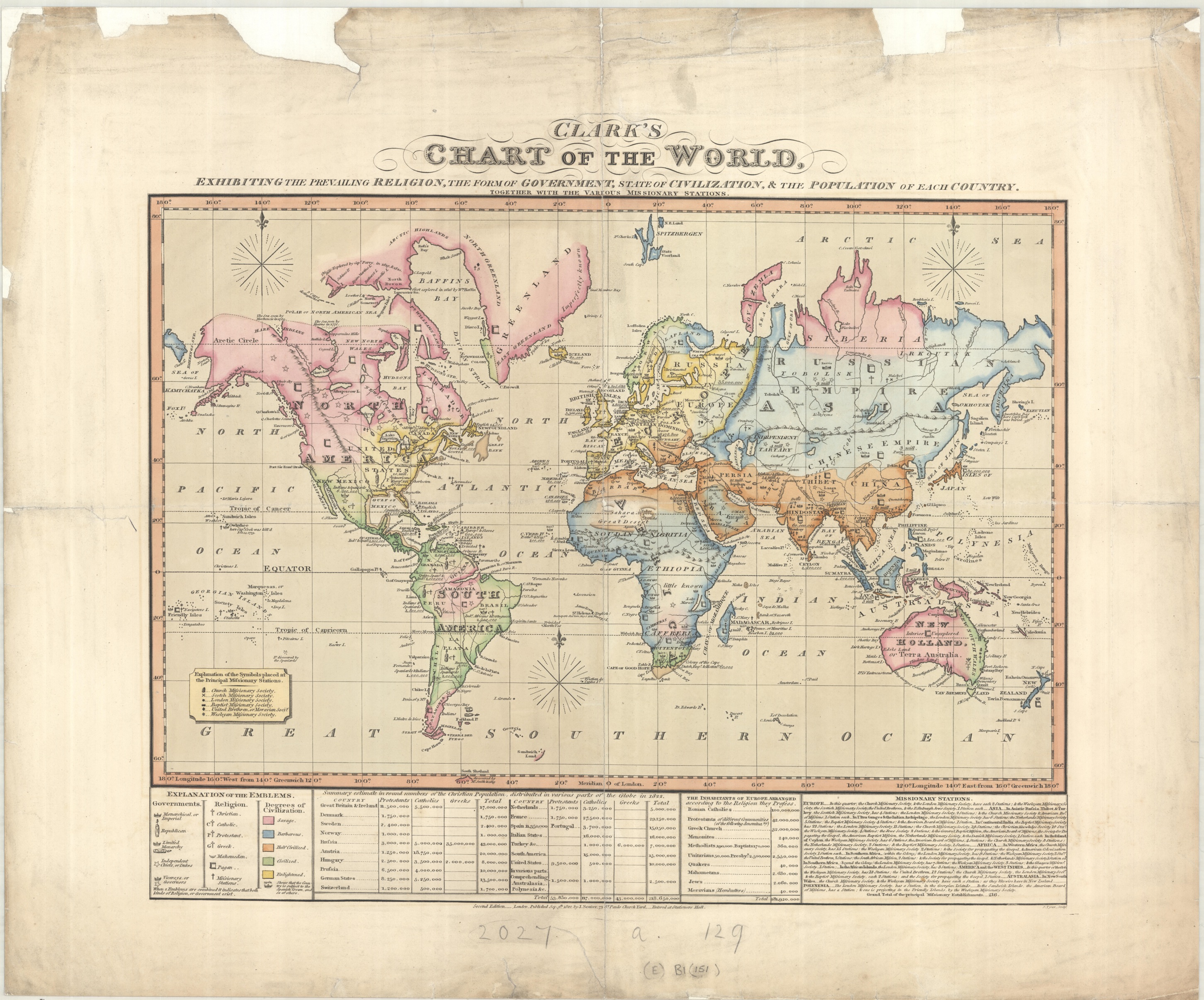
Clark’s Chart of the World, 2nd ed, 1822. (E) B1 (151)

clarks.jpg crop

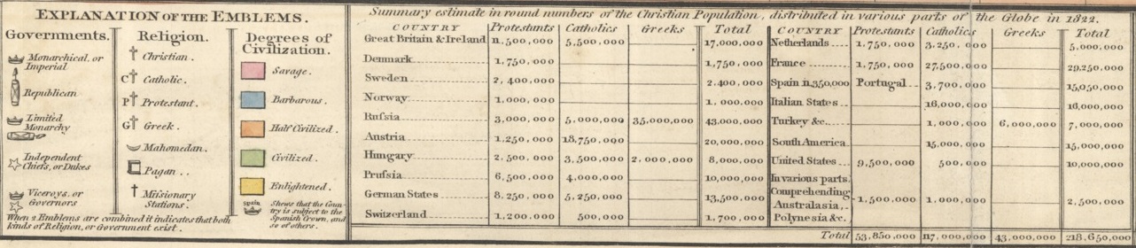
inset of Clark’s Map showing population table and legend

But at the same time different ways to portray population figures were being introduced. This map, from 1849, shows the population of Britain based on figures from the 1841 census by using dots to show sizes of cities, towns and villages as well as shading to show general population density.

eluc

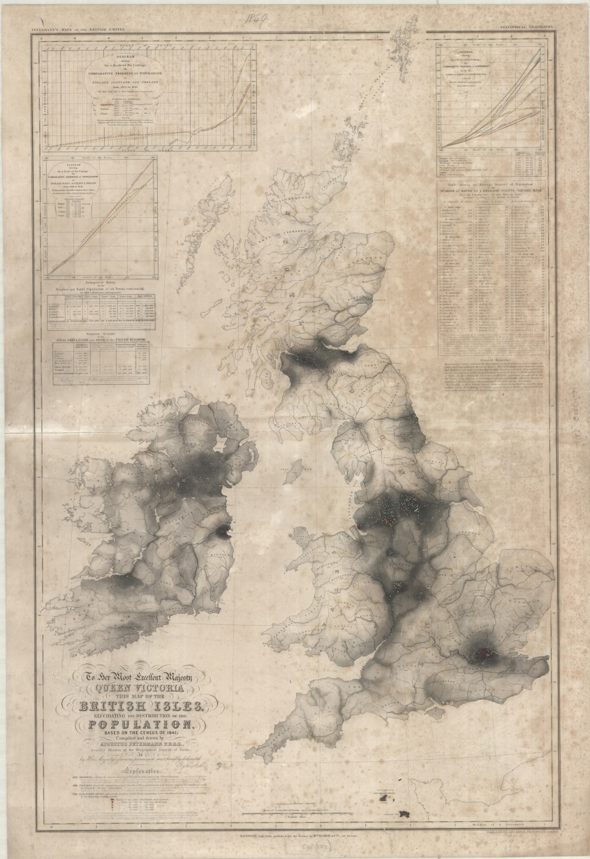
British Isles elucidating the distibution of the population…1849, (E) C15 (157)

Our original map of Saxony uses a technique called isopleth to show the density of population. Isopleth uses lines to show areas of equal value, the lines are similar to contours on a physical map and work on the same principle. The main advantage is that you can see at a glance the heavily populated areas by the colour ranges shown on the graph. That Saxony was, in 1900, a mainly rural area can be seen be the amount of green and brown cover shown.

dresden

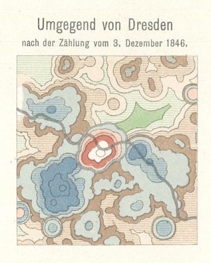
Inset from Volksdichte-Schichtenkarte des Königreiches Sachsen showing Dresden according to 1846 census


A list of selected accessions to the map collection in April 2015

Argentina Political Divisions, OSS A-3856. 1944. H3 (222)

L’Hellenisme depuis l’antiquite jusqu’a nos jours, 480 av-J.C. 1921, 1921? C8 (309)

Notes on the Italian Theatre of War and short vocabulary, 1917. War Office, includes glossary and key phrases translated into Italian, text and map of North Italy (G.S.G.S. 2846) C25:1 e.1

Argentina Corn Map – World Statistics, 1939. Published by Sanford Evans Statistical Service. Features tables on corn production, exports and imports etc. H3:5 (17)

Océan Glacial Arctique Spitzberg. Région des travaux de l’expédition de l’Académie de Sciences de Russie pour le mesure d’un arc de méredien en 1899-1901, Académie des Sciences de Russie. M9 (121)

Stadtplan von Istanbul,1940. Generalstab des Heeres. D30:80 Istanbul (32)

Map of the Empire Mail Scheme and other Commonwealth air routes in the Eastern Hemisphere (existing and projected) 1938. 1937, War Office. B4 (135)

Map and guide of Abha and Khamis…, c1988. D50:9 (4)

Catal Agzi liman inkiʂafi. 1938. 3 maps and a diagram on the Ereĝli coal basin in Turkey. D30:3 (22)

Airfields and enemy dispositions, Amami-Gunto and Okinawa-Gunto, OSS No 5509. 1944. D20:46 (3)

Physical chart of North Polar Regions, plotting route of ‘Fram’ and Fridjtof Nansen. 1897. B2 (142)

Cholera epidemic 1863-1868. 1952. B1 (1488)

Gallipoli

Bodleian’s collection of maps covering the Gallipoli campaign comes mainly from two sources. As well as a wide range of maps published by the War Office the library holds a number of detailed maps of the peninsula showing defences and trenches published by the General Staff of the Turkish Army. The Turkish maps are of interest because these, published before the First World War, were used by the WO as the main source of information for their detailed maps of the area.

gall turk

This Turkish trench map dates from 1912, and would have been produced in response to the threat posed by Bulgaria in the First Balkan War. This map, and others in the series, were copied by the Geographical Section, General Staff  of the War Office to create their maps of the Peninsula. The British map based on this Turkish one can be seen below. This map shows the area around Anzac Cove. D30:3 (13)

The Dardanelles, the strip of water between the Gallipoli Peninsula and Turkey-in-Asia, is an important link from the Mediterranean to the Black Sea. Allied control of this waterway would then make the taking of Constantinople (as Istanbul was called at the time) a serious possibilty, and it was hoped that this threat would be enough to end Turkish involvement in the war.

The campaign, which started with a Naval bombardment of Turkish defences along the peninsula in February 1915 is now regarded now as a military mistake, the blame of which was directed towards Winston Churchill, at the time First Lord of the Admiralty. It is also a source of national pride in Australia and New Zealand, where ANZAC Day is remembered every 25th of April, marking the date when troops from the two countries first landed at Gallipoli. At the time though Gallipoli was seen as a way of easing pressure on the Western Front, where after the initial fighting at the start of the war had been replaced by the stalemate of trench warfare. Taking the fight to Turkey also had other advantages. Two successive wars in the Balkans leading up to 1914 had weakened the Ottoman Empire and a campaign against Turkey was sure to win the support of the neighbouring nations; soon Bulagira broke off negotations with Germany while Greece offered troops and Italy, as yet undecided as to who to support began to lean towards the Allies.

Following the initial bombardment in February ships from the French and British navies moved into the Dardanelles on March the 18th, intending to take out of action the forts lining the shores in preparation for troop landings. Minefields had been identified in earlier reconnassaince but after several ships were hit and were sunk by mines the naval bombardment was called off, leaving defences in place when Allied troops landed on the 25th of April. Anzac troops were scheduled to land at Anzac cove but instead landed a mile north and faced steep slopes and

gall brit

The British version of the Turkish map, again centring on Anzac Cove. Dating from 1915 the map includes instructions on the right in both English and French in how to use the squares on the map to pinpoint positions. D30:3 (20) [407]

defended positions, and soon began to suffer heavy casualties. British and French forces fared better. British troops landed at Cape Helles where on some beaches oppostion was minimal while on others deadly, and were able to move inland and set out forward lines. This was all to no avail though. As in France and Belgium fighting soon took the form of trench warfare as soldiers were forced to dig in. By late 1915 the operation was finally cancelled and by January 1916 all Allied troops had been evacuated off a Peninsula that 265,000 of their commrades had died trying to win.

helles

Capes Helles from the same series as the map of Anzac Cove by the War office, 1915. D30:3 (20) [11]

As well as official maps produced by the two opposing armies commericial maps began to appear soon after the campaign started. Papers such as the Daily Telegraph and publishers Stanfords produced maps which were bought by the public as a way of following the campaign, either from a sense of interest or from a more personnal reason, to learn about the terrain and area where family or friends were based.

telegraph

The Daily Telegraph War map no. 9, The Dardanelles, 1915. D30:3 (3)

A list of selected accessions to the map collection in March 2015

Standard map of the Witwatersrand Goldfields, 1900. E54:13 (90)

Nordwest-Pamir, Alai-Pamir Expedition 1928, 1931. C40:22 (12)

Map of Poland and adjacent countries shewing nationalities, languages & religions, 1943. C31 (498)

International General Aeronautical Map Britain. G.S.G.S. (Air) No. 113, 1924. Published by the Air Ministry. C16 (851)

Map of Axis annexations, occupations and the puppet states from March 1938 till October 1943, 1943. C1:5 (553)

axis

Roma e Dintorni, 1935. Istituto Geografico Militare. C25:15 (37)

Plan von Berlin und umgegebend bis Charlottenburg, c.1900. C22:45 Berlin (120)

Map of the Kingdom of Siam and its dependencies, [1900?]. D28 (210)

Formosa from the latest Japanese Government surveys, 1901. D21 (137)

Environs of Oxford, enlarged from the Ordnance maps; the Geological Survey & sections by Andrew Stacpoole…New College, 1920?. C17:49 (313)

The Sheldon Tapestry and the Weston Library

The official re-opening of the Weston Library took place over the weekend of the 21st and 22nd of March. After a four-year refit which saw the central book stack – eleven floors filled with books, maps, newspapers and everything else you could imagine (even a ghost on one of the floors) – taken out and re-placed by Blackwell Hall, a large open space open to the public and featuring permanent and temporary exhibitions of Library treasures. The current exhibition, Marks of Genius (http://www.bodleian.ox.ac.uk/weston/news/2015/feb-27) features some of the most celebrated items in the collection, amongst which is one of the Map Department’s most important possessions, The Gough Map (http://www.goughmap.org/).

Taking up a key position in the hall is the famous Sheldon Tapestry map of Worcestershire. Handwoven from wool and silk around 1590 this map is one of four large tapestries that were originally hung in Weston house, the home of Ralph Sheldon.

Tapestry Full_new_v2

Of the four tapestries, the Bodleian owns Worcestershire and Oxfordshire, both of which came to the Library in 1809 as part of a large donation by the antiquarian Richard Gough (it was in this donation that the Library also acquired the Gough Map). The Library owns parts of the Gloucestershire map while Warwickshire is on display at the Warwickshire Museum. Worcestershire has recently been conserved, a project involving the National Trust’s tapestry conservators. Details of how they achieved such spectacular results can be found here https://nttextileconservationstudio.wordpress.com/

The map is on display in the hall for at least the next year, while the Marks of Genius exhibition, including the Gough Map amongst other items, finishes on the 20th of September.

A list of selected accessions to the map collection in February 2015

Yellowstone National Park, 1907. United States General Land Office. F6:58 (39)

Map of the British Central Africa Protectorate, prepared from a drawing compiled at the Intell: Div: War Office for H.H. Johnston, C.B., H.M. Commissioner and Consul General, B.C.A. 1895. Royal Geographical Society (RGS), March 1895. E40 (194)

Karte des Europäischen Russlands und der Angrenzenden Länder, mit genauer bezeichung der strassen und angabe einiger historich-physikalisch-geaograpischen hauptomente, 1885. Justus Perthes. C40:6 (165)

Sketch map of Syria, Topographical Section, General Staff No 2067, 1907. Shows Aleppo to Medina railroad. D27 (142)

Railways of Greater Germany, Map No 2992, 1944. Branch of Research and Analysis, OSS. C22 (666)

Navarra, 1861. From the ‘Atlas de España y Sus Posesiones de Ultramar’. Includes text and plans of Pamplona, Estella and Tudela. C38:13 (14)

Nanga Parbat-Gruppe und nachbargebeite, 1936. From the Deutsche Himalaya-Expeition 1934. D11:3 (2)

Scheme of the Political and Administrative Divisions of the U.S.S.R., c1939. Also includes geological and mineral information. C40 (431)

SOVIET

Southeastern Siberia, ethnic groups, 1944. No 5904 – R & A, OSS. C40:4 (33) and Southeastern Siberia, distribution of population, 1944. No. 5903 – R & A, OSS. C40:4 (34)

Übersichtskarte für die Russischen Besitzungen in Mittelasien, c1900. Published by E.S. Mittler & Sohn, Berlin. D1:5 (60)

Alai-Pamir Expedition 1928. Fedtschenko-Tanimasgebiet, 1930. Joint publication by the ‘Notgemeinschaft der Deutschen Wissenschaft mit Unterstützung der Akademie der Wissenschaften der U.S.S.R’. C40:22 (11)

W & A.K. Johnston’s Russo-Japanese war map, 1904. D1:4 e.2

Paul Langhans: Die wirtschaftlichen beziehungen der Deutschen küsten zum meere, 1900. Justus Perthes. C22:1 (20)

The economic wealth of Germany, 1919. Supplement to The National Review, February 1919. C22 (668)

Compass traverse of a journey across the Ordos by Major George Pereira, 1911. RGS. D7 (138)

Panoramic view of the Crater Lake National Park, Oregon, c1900. U.S. Geological Survey. F6:45 (35)


Blowin’ up a storm

It’s not often you come across a sense of bitterness from a map. Usually they are pretty emotionless objects, simply showing the authours intentions, unless the subject is one to stir the heart; a plan of a battle maybe, or pre-war ethnic maps of Europe which have such weight of forthcoming events.

huricane 1

This Hurricane map of the Caribbean and Eastern Seaboard seems a first glance to be straight-forward weather map,compiled from information supplied by the United States Weather Bureau. This first scan shows the right-hand part of the map. A second image from the map though shows a note attached by an

hurricane 2

unknown hand in the top left corner, critizing the Bureau for missing the severe hurricane of 1929, as the Americans ‘were too busy chasing piratical English Boot-Leggers to worry about Weather Bureaus notifying the Bahamas Govt.’.

1941 Hurricane Map, compiled from authentic data furnished by the United States Weather Bureau,  1941. G10 (138)


The Russo-Japanese war

This map of the Russo-Japanese war of 1904-05 is an interesting new addition to Bodleian’s collection. The map, which is too large to scan and show here as one, has a number of insets of different areas of conflict as well as a picture of the flags of the countries involved and a booklet

cover (2)

within the cover giving a brief background to the causes of the war and military information on each of the four powers involved; Russia and Japan as the major opponents with China and Korea as interested observers. The booklet gives as a main reason for the war as Russia’s need for a sea-port open all year. Russia obtained permission to run the trans-Siberian railway through Manchuria (which, following the end of the Chinese-Japanese war in 1894 and defeat of

asia rus war

the Chinese Japan had claimed, only to be forced into giving up this land by Russia, France and Germany) and, as the booklet tells us ‘Russia promised to end her military occupation of Manchuria by 8th of October 1903; but once in possesion she is difficult to dislodge, and she is still there yet, and not only there, but she has sent an army and a fleet to the East as a gentle hint to Japan that she has come to stay’.

flag

Despite this gentle hint Japan went on to win the war after inflicting numerous defeats on the Russian forces both on land and at sea.

W & A.K. Johnston’s Russo-Japanese war map, 1904. D1:4 e.2

A list of selected accessions to the map collection in January 2015

The Blue Mountains from Lawson to Lithgow, 1909. A beautiful map showing the mountains in profile with geological features coloured. I3:10 (53)

Sketch map of the Turco-Greek frontier and adjoining districts, 1897. Map published by the Intelligence Department of the War Office. C5 (286).

Fortress of Adrianople, G.S.G.S. 2418, 1912. Detailed map of the town and area at time of siege, showing forts etc. D30:30 (3)

Distribution of Iron Ores of the Lake Superior District, 1909. Shows imports of Iron Ore into the Northeastern States. Published by the U.S.G.S. F6:2 (94)

Geological map Bougainville and Buka Islands, Territory of Papua New Guinea, 1967. Published by the Bureau of Mineral Resources, Australia. D44:11 (7)

Papua New Guinea 1:250,000 Geological Series, 1972-74. Published by Bureau of Mineral resources, Australia. Bodleian has 2 sheets of a set. D44 (63).

Curragh and vicinity, manoeuvre map, 1895. I.D., W.O., No 1109. War Office. C19:22 (9).

The Island of St. Kilda, from a survey by J. Norman Heathcote…, 1900. Map to illustrate paper in Feb. 1900 Geographical Journal. C18:44 (4)

Magna Britannia complectens Angliae, Scotiae et Hiberniae regna : in suas provincias et comitatus divisa / repraesentante Io. Bapt. Homann (1713). Published by Johann Baptist Homann, Nuremberg, 1713. (E) C15 (952). Another edition of this map published around 1715 was also acquired, shelfmark (E) C15 (953). These are both later states of the map first published in Atlas Novus in 1707.

A collection of eighteenth and early nineteenth century maps of administrative divisions  in Germany, from the period of the Holy Roman Empire. Published in Nuremberg by Homann Erben and in Weimar by Industrie-Comptoirs between 1702 and 1808.

Tibet township map & place name index = Bod kyi grong brtal dang grong tsho’i sa khra / designed and edited by Tsering Wangyal (2014). Published Princeton, New Jersey by Tsering Wangyal Shawa. D8 (121)

Sir Winston Churchill

This month marks the 50th anniversary of the death of Sir Winston Churchill. His funeral took place on Saturday the 30th of January, 1965.

Churchill’s life was so eventful it would be possible to feature any number of maps of places or events in which he was involved; Gallipoli, Omdurman, Blenheim Park or Chartwell are just a few of many examples. We chose to display here two from the Bodleian collection. The first is a map from a supplement published in the Radio Times to mark his passing, and shows the processional route his coffin and guard would take through London on the day of his funeral. As well as an historical document of an important event it’s an interesting example of how maps can appear in unlikely places, in this instance a television listings magazine. (The magazine is tightily bound in a volume which includes all the editions for the first half of 1965, hence the distortion in the middle of the image).

churchill

Radio Times, South & West ed. Vol 166-167, Jan-June 1965. Per 247933 c.17

The second is a trench map form the First World War, and shows the area around Ploegstreet and the positions of British and German trenches. After resigning from Governement in 1915 following the failure of the Gallipoli campaign Churchill joined the Army, becoming a Lieutenant-Colonel in the Royal Scots Fusiliers, and for part of 1916 was in command of a battalion on the

trench

front line here. On the map the blue lines represent the British trenches, the red the German. Churchill’s headquarters while at the front was based in Laurence Farm.

Ploegstreet 1:10,000, Edition 4A, trenches corrected to 7-12-16. 28 S.W. 4. C1 (3) [800]